





Spotlights
GIS Analyst, Spatial Data Analyst, Remote Sensing Analyst, Cartographer, Geospatial Data Scientist, GIS Specialist, Geomatics Analyst, Geospatial Technician, Location Intelligence Analyst, Geospatial Information Scientist, GIS Developer, Geospatial Consultant
Every time you use a map app for directions, explore environmental changes, or analyze urban growth, geospatial analysts have played a key role behind the scenes. Their work transforms raw geographic data into clear, actionable insights that impact city planning, disaster response, agriculture, and more.
Geospatial Analysts spend their days collecting and interpreting geographic information from satellites, drones, and various sensors. They collaborate closely with scientists, urban planners, emergency responders, and government agencies to create detailed maps, models, and reports that support decisions about land use, natural resources, and public safety.
Using specialized software like GIS platforms, remote sensing tools, and spatial databases, these analysts process complex data to reveal patterns and trends invisible to the naked eye. Their expertise ensures that important decisions are based on accurate, timely geographic information, making their role essential in solving real-world challenges.
- Helping communities prepare for natural disasters by mapping risk zones.
- Seeing your data visualizations guide important environmental or urban planning decisions.
- Collaborating with experts across science, government, and technology fields.
- Turning complex geographic data into clear, impactful stories that influence policy and action.
Working Schedule
Geospatial Analysts typically work full-time in office environments, but many also engage in fieldwork to collect data. While most have regular business hours, project deadlines or urgent needs—like disaster response—can require extra hours or flexible scheduling. Many work for government agencies, private firms, or research institutions, with some freelancing on specialized projects.
Typical Duties
- Collect and process geographic data from satellite imagery, aerial photos, and sensors.
- Create detailed maps and spatial models using GIS (Geographic Information Systems) software.
- Analyze spatial data to identify trends in land use, environmental changes, or resource distribution.
- Collaborate with scientists, planners, and policymakers to understand data needs and deliver actionable insights.
- Develop databases to manage geospatial information efficiently and accurately.
- Use remote sensing technologies to monitor changes in landscapes, vegetation, and urban development.
- Prepare reports and visual presentations to communicate findings effectively to stakeholders.
- Maintain and update GIS databases to ensure data accuracy and accessibility.
- Assist in designing and implementing location-based technology solutions.
- Support emergency management teams by providing real-time geospatial data during crises.
- Validate data quality through field verification and cross-referencing multiple sources.
- Stay up-to-date with new geospatial technologies and methods to improve analysis.
Additional Responsibilities
- Train team members or clients on GIS tools and data interpretation.
- Contribute to grant writing or project proposals involving spatial data analysis.
- Participate in community outreach to explain geospatial projects and their benefits.
- Ensure compliance with data privacy and security regulations related to location information.
- Develop custom software tools or scripts to automate geospatial workflows.
- Consult on integrating geospatial data with other technologies like AI or IoT.
- Attend conferences and workshops to stay informed about industry trends.
- Collaborate on interdisciplinary research projects involving spatial analysis.
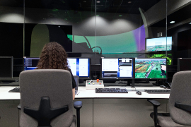
Morning starts with reviewing new satellite data or sensor feeds collected overnight and checking for any urgent requests from partners or emergency teams. Analysts prioritize tasks based on project deadlines and data availability.
Midday is often focused on hands-on work with GIS software—processing raw data, running spatial analyses, and building maps or 3D models. This involves careful attention to detail and troubleshooting unexpected data issues.
Later in the afternoon, analysts meet with colleagues from other departments or external clients to discuss findings, gather feedback, and plan next steps. They may also prepare reports or presentations summarizing their latest insights for decision-makers.
Soft Skills
- Attention to detail
- Critical thinking
- Problem-solving
- Effective communication
- Collaboration and teamwork
- Adaptability
- Curiosity and eagerness to learn
- Time management
- Analytical mindset
- Patience and persistence
- Creative visualization
- Customer service orientation
Technical Skills
- Proficiency with GIS software such as ArcGIS and QGIS
- Remote sensing and image analysis
- Spatial data modeling and database management
- Programming languages like Python or R for data manipulation
- Knowledge of GPS and surveying equipment
- Data visualization and cartographic design
- Understanding of spatial statistics
- Use of satellite and drone imagery
- Familiarity with cloud computing platforms for geospatial data
- Ability to integrate geospatial data with AI and machine learning tools
- Remote Sensing Analyst: Focuses on interpreting satellite and aerial imagery to monitor environmental and land changes.
- GIS Developer: Builds and customizes GIS software applications to meet specific organizational needs.
- Cartographer: Specializes in the art and science of map-making, focusing on visual design and clarity.
- Location Intelligence Analyst: Combines GIS with business data to support marketing, logistics, and retail decisions.
- Geospatial Data Scientist: Applies advanced statistical and machine learning techniques to analyze spatial data.
- Environmental Geospatial Analyst: Uses GIS to study ecosystems, natural resources, and environmental impacts.
- Urban Planner Geospatial Analyst: Supports city planning through spatial analysis of infrastructure and population data.
- Disaster Management Geospatial Analyst: Provides real-time mapping and analysis to aid emergency response efforts.
- Government agencies (e.g., USGS, FEMA, EPA)
- Environmental consulting firms
- Urban planning and architecture firms
- Agricultural technology companies
- GIS software and technology companies
- Research universities and institutes
- Non-profit environmental organizations
- Defense and intelligence agencies
- Mapping and surveying companies
- Disaster response organizations
- Utilities and infrastructure providers
- Transportation and logistics companies
Geospatial Analysts often work under tight deadlines, especially when their analyses support urgent projects like disaster response or environmental assessments. Accuracy is critical, so the job requires meticulous attention to detail and the ability to double-check data from multiple sources.
While the typical workweek is Monday through Friday, projects can demand extended hours or quick turnarounds, particularly during emergencies or grant submission periods. Fieldwork may also involve travel and outdoor conditions, adding to physical demands.
Professionally, analysts must stay current with rapidly evolving technologies and data sources. Continuous learning and adaptability are essential, as is balancing technical work with effective communication to non-expert stakeholders.
- Increasing use of artificial intelligence and machine learning to automate spatial data analysis.
- Growing integration of real-time data from drones and IoT sensors into GIS platforms.
- Expansion of cloud-based GIS solutions allowing remote collaboration and big data processing.
- Greater emphasis on data privacy and ethical use of location information.
- Use of augmented reality (AR) and virtual reality (VR) for immersive geographic visualizations.
- Rising demand for geospatial data in climate change research and sustainability planning.
- Development of user-friendly GIS tools accessible to non-specialists.
- Advancements in satellite technology providing higher-resolution imagery.
- Cross-disciplinary collaboration between geospatial analysts and data scientists.
- Incorporation of blockchain for secure geospatial data management.
Many geospatial analysts were drawn to puzzles, map reading, and exploring the outdoors as kids, fascinated by how places fit together and change over time. They often enjoyed video games or activities involving spatial reasoning and problem-solving.
Early skills like curiosity about geography, interest in computers and technology, and a knack for organizing information often hinted at a future in geospatial analysis. Participating in science clubs, geography bees, or computer programming camps can be early signs of this career path.
Most Geospatial Analysts hold at least a bachelor’s degree in geography, GIS, environmental science, computer science, or related fields. Specialized training in GIS software and spatial analysis is crucial, and many professionals pursue certifications or advanced degrees to deepen their expertise.
Students can take courses in relevant subjects such as:
- Geographic Information Systems (GIS)
- Remote Sensing and Image Analysis
- Cartography and Map Design
- Spatial Statistics
- Programming for Spatial Data (Python, R)
- Environmental Science
- Data Visualization
- Database Management
- Geodesy and Surveying
- Urban and Regional Planning
Hands-on experience through internships, research projects, or volunteer work is highly valued to build practical skills. Developing a strong portfolio of maps, analyses, and projects can showcase your capabilities to future employers. Continuous learning is important as technology and data sources evolve.
- Take advanced math courses such as algebra, geometry, and statistics.
- Enroll in computer science or programming classes to build coding skills.
- Study geography and earth sciences to understand spatial concepts.
- Participate in clubs like robotics, coding, or environmental science.
- Learn to use basic GIS software or mapping apps available to students.
- Practice problem-solving and critical thinking through puzzles and games.
- Seek out summer programs or workshops related to GIS and technology.
- Develop strong writing and communication skills for reporting findings.
- Engage in science fairs or geography bees to build related knowledge.
- Connect with mentors working in geospatial or environmental fields.
- Explore online tutorials or courses in GIS and spatial analysis.
- Volunteer for community projects involving mapping or data collection.
- Choose programs with hands-on GIS and remote sensing labs.
- Look for schools offering internships or partnerships with local government or companies.
- Consider programs that teach programming languages relevant to spatial data.
- Check for faculty with active geospatial research or industry connections.
- Ensure curriculum covers both technical skills and communication.
- Seek programs emphasizing real-world problem-solving projects.
- Verify access to up-to-date GIS software and technology.
- Find programs that include training on data privacy and ethics.
- Look for opportunities to work on interdisciplinary teams.
- Choose schools with strong career services and networking events.
- Opt for classes that teach data visualization and storytelling.
- Prioritize programs offering certificates or advanced degrees in GIS.
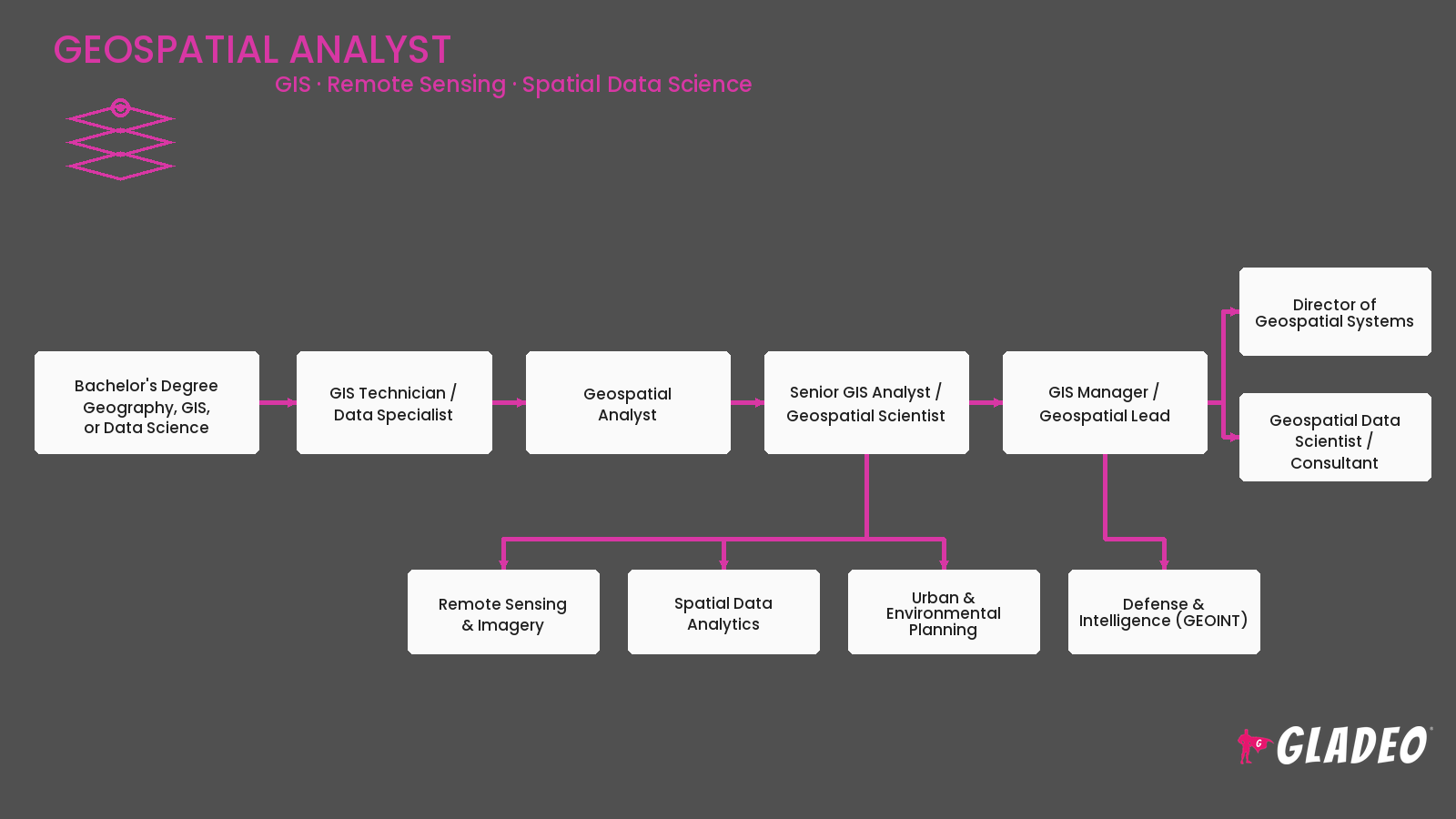
- Build a portfolio showcasing GIS projects, maps, and spatial analyses.
- Apply for internships or entry-level GIS technician roles.
- Volunteer to assist with mapping projects in community organizations.
- Network with professionals through LinkedIn and industry events.
- Create a personal website or online portfolio to display your work.
- Develop proficiency in key GIS software like ArcGIS and QGIS.
- Practice programming skills relevant to spatial data management.
- Seek mentorship from experienced geospatial analysts.
- Prepare for interviews by practicing explanations of your projects and tools.
- Stay current with industry news and emerging technologies.
- Apply to government internships or fellowships related to GIS.
- Gain experience with data collection tools like GPS units and drones.
- Master advanced GIS software features and spatial analysis techniques.
- Develop leadership skills to manage projects and teams.
- Gain expertise in niche areas like remote sensing or urban planning.
- Build a professional network by joining geospatial organizations.
- Contribute to publications or present at conferences.
- Pursue certifications such as GISP (GIS Professional) or specialized credentials.
- Expand skills in programming and data science to handle big data.
- Seek roles with increasing responsibility, such as GIS manager or consultant.
Websites:
- Esri (esri.com) — Leading GIS software company with resources and training.
- GIS Lounge (gislounge.com) — News, tutorials, and career advice.
- American Society for Photogrammetry and Remote Sensing (asprs.org) — Professional society for geospatial professionals.
- Urban and Regional Information Systems Association (urisa.org) — GIS education and networking.
- GeoNet (community.esri.com) — Online community for GIS users.
- National Geographic Information System (ngis.org) — Educational resources.
- OpenStreetMap (openstreetmap.org) — Collaborative mapping project.
- GIS Certification Institute (giscertification.org) — Certification information.
- Geospatial World (geospatialworld.net) — Industry news and analysis.
- Directions Magazine (directionsmag.com) — GIS industry insights.
- GIS Stack Exchange (gis.stackexchange.com) — Q&A for GIS professionals.
- DroneDeploy (dronedeploy.com) — Drone mapping and analysis tools.
- Spatial Thoughts (spatialthoughts.com) — GIS tutorials and blog.
- Federal Geographic Data Committee (fgdc.gov) — Government geospatial policy and standards.
Books:
- GIS Tutorial 1: Basic Workbook by Wilpen L. Gorr and Kristen S. Kurland
- Getting to Know ArcGIS Pro by Michael Law and Amy Collins
- Remote Sensing and Image Interpretation by Thomas M. Lillesand, Ralph W. Kiefer, Jonathan W. Chipman
- Python Scripting for ArcGIS by Paul A. Zandbergen
- Designing Better Maps: A Guide for GIS Users by Cynthia A. Brewer
If you love working with maps, data, and technology but want to explore other paths, there are many related careers where your skills can shine.
- Cartographer: Focuses on creating visually compelling and accurate maps.
- Environmental Scientist: Studies natural processes and human impacts on the environment.
- Urban Planner: Designs and manages land use and community development.
- Data Analyst: Works with various types of data to identify trends and support decisions.
- Remote Sensing Technician: Operates equipment that collects aerial and satellite imagery.
- GIS Developer: Builds software tools and applications for geospatial analysis.
- Surveyor: Measures and maps land boundaries and features.
- Location Analyst: Uses spatial data to help businesses optimize site selection and marketing.
- Climate Analyst: Studies climate patterns using spatial and statistical data.
- Geographer: Researches physical and human geography to understand spatial relationships.
Newsfeed

Featured Jobs
Online Courses and Tools